Forecasters have warned Storm Eowyn could be ‘exceptionally dangerous’ as the Met Office issued an upgraded amber weather warning for a large section of the UK on Friday.
Amber and yellow weather warnings are in place for Friday into Saturday, as BBC forecaster Chris Fawkes warned that the ‘risk-to-life’ winds will lead to disruptions such as damage to buildings, power cuts and flying debris.
The storm is predicted to disrupt travel, with road, rail, airports and ferries likely to be affected.
Eowyn, the fifth-named storm of the season and the first of 2025 could bring winds of 90mph or even higher in the worst affected areas.
Storm Eowyn is expected to make landfall in Ireland on Thursday before moving onto Great Britain on Friday when yellow weather warnings come into effect.
BBC weather forecaster Chris Fawkes said on Wednesday morning that the storm was “exceptionally dangerous“, adding: “It may be the strongest system we’ve seen across this part of the world since storm Debbie hit in the 1960s… These warnings are going to need to be upgraded in time.”
Storm Debbie, also known as Hurricane Debbie, caused significant flooding and damage in September 1961. It led to the deaths of 15 people in Ireland and brought record rainfall, with some areas receiving over 300mm in 24 hours, resulting in widespread flooding and destruction.
While the UK did not experience the same level of devastation, Scotland and parts of northern England experienced heavy rainfall and some flooding from Debbie’s remnants.
The change to conditions this week is being caused by a powerful jet stream pushing low pressure across the Atlantic and towards the UK, following a recent cold spell over North America, the Met Office said.
On Thursday a wind warning is in place from 7am to 6pm covering most of the coast of Wales and all of the South Coast.
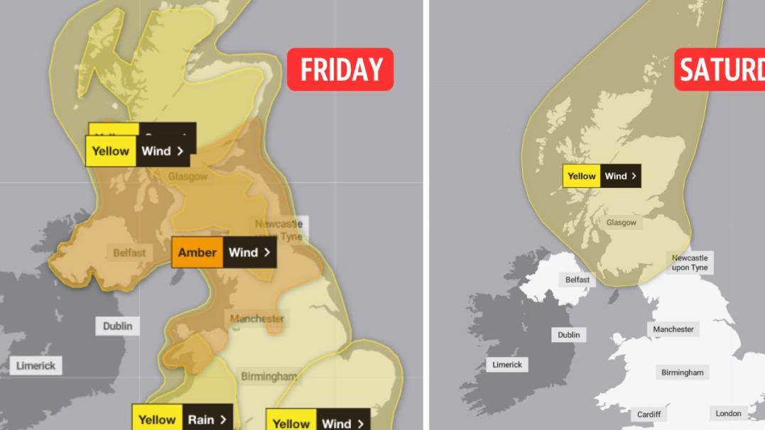
As Storm Eowyn hits on Friday, amber weather warnings are in place covering an area from north of Manchester, north Wales and Scarborough, up to southern Scotland, north of Glasgow and Edinburgh.
The amber warnings for ‘very strong wind and widespread disruption’ mean power cuts and travel disruption are likely to occur, along with possible damage to buildings as roofs could be blown off and power lines brought down.
The rest of the country is covered in yellow warnings for wind, with some disruption expected. There is also a yellow snow warning covering much of Scotland and northern England which expires at midday on Friday.
A yellow warning for heavy rain is also in place for the southeast of England and most of Wales from midnight on Thursday until 9am on Friday.
Moving into Saturday all of the warnings will have expired except for the wind one covering Scotland and the top of North England, which will end at 3pm.
Amber and yellow weather warnings in place across the UK on Friday 24 and Saturday 25 January. (Met Office/Yahoo News UK)
The Met Office said winds this weekend could reach 60-70mph inland and 80-90mph along some coasts and hills – perhaps even higher in a few locations – in the North of England, southern Scotland and Northern Ireland.
Elsewhere, winds are expected to range between 50mph and 70mph. Wind strength is expected to gradually ease through Saturday from the south.
Average wind speeds expected in northern Scotland at 6pm on Friday. (Met Office)
Met Office deputy chief meteorologist Mike Silverstone said: “The strongest gusts are likely to be felt across parts of Northern Ireland, northern England, north-western Wales and western Scotland, where exposed sites could get gusts in excess of 80mph, which has the potential to cause impacts for those in these areas.
“There will also be some heavy rain, bringing some unpleasant conditions to end the week.”
Another area of low pressure could bring further wet and very windy weather across the UK by Sunday, the Met Office said.
The last named storm to hit the country this season, Storm Darragh, on 6 December, saw a rare red warning issued, with winds peaking at 96mph at Barry Head in Devon.
For those of you wondering, no, it is not an Irish spelling of the name “Owen”.
The Met Office’s Andrea Bishop said during a forecast of the storm that the name is pronounced: “Ay-oh-win.”
Issuing guidance to those affected by the yellow warning area, the Met Office advises people to check for loose items outside their homes and think about how to secure them to protect their property.
This could include bins, garden furniture, trampolines, tents, sheds, and fences.
Travellers should give themselves the best possible chance by checking road conditions if driving, or bus and train timetables, to avoid delays.
Stocking up on torches, batteries, a mobile phone power pack and other essentials will help in the event of a power cut.
Those near the coast should take care if walking near cliffs, should be sure of the route they are taking and should keep dogs on a lead. Even from the shore, large breaking waves can sweep you off your feet and out to sea, the Met Office warns.
Be prepared for weather warnings to change quickly, the forecaster adds, advising people to stay up to date with forecasts in their area.
Read more


