Quiet and seasonably cool conditions will take us through Friday before a potent winter storm takes shape this weekend. A small area of sprinkles and flurries may persist for a few hours this evening mainly over Northcentral Kansas, but no accumulations are expected.

Tonight’s lows will drop to the teens and 20s.

With a wind shift due to a weak cold front, temps will be slightly lower on Friday, but it will not be a big change in the chill until the weekend.

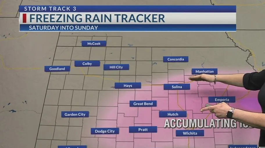
Travel conditions will rapidly deteriorate from Saturday afternoon through Sunday. I would advise finishing any errands Saturday morning before the system intensifies. A Winter Storm Watch is in effect from midday Saturday through Sunday evening. This is when and where the highest accumulations of sleet, freezing rain and snow will take place.

Winter Weather Advisories are posted for counties in Western and West-Central Kansas. Lighter accumulations of ice and snow are expected in this area.

The system begins Saturday afternoon with rain near the Oklahoma state line. Freezing rain to sleet will be more likely near and north of Highway 400 to just south of the Nebraska state line, to start. Some snow will be possible first near the Nebraska state line on Saturday before spreading southeast into northern and western Kansas Saturday night through early Sunday morning.

Winds will also intensify Saturday night. Sustained winds of 15-30 MPH with gusts from 35-45 MPH will be possible from Central into Eastern Kansas Saturday night into Sunday. With ice/budding snow accumulations and near blizzard strength winds, visibility will be reduced on area roads and power outages may be possible.

We will hit a midnight high in Wichita on Sunday before temps crash due to the influx in Arctic air. We could be looking at afternoon temps in portions of Kansas in the single digits and teens! Freezing rain/sleet will get pushed aside for all snow once the column of air cools from northwest to southeast. In the end, we could be looking for several inches of snow to fall farther north/northeast.

This will fall over a layer of ice with the highest accumulations pinpointed for folks under the Winter Storm Watch and highlighted in the pink.

We will be dealing with the lingering effects of this system for the Monday morning commute. I suspect there will be multiple school closings due to the ice/snow/dangerous cold. Temperatures from Monday through Wednesday of next week, will not get above freezing. There is some improvement in area temperatures by Thursday before another colder drop on Friday. Temperatures will remain below average into the following weekend.

There is another system that will skirt by us on Tuesday. The Colorado Rockies will benefit from snow. We may see some across Southwest Kansas and the Oklahoma Panhandle Tuesday evening into the overnight. Amounts look light since the system will be brief.

Another piece of energy may squeeze out a raindrop or a flurry the following Friday night, however, drier air may eat at this chance.
KSN Storm Track 3 Forecast from Chief Meteorologist Lisa Teachman:
Wichita:Tonight: Partly cloudy. 10% of sprinkles and flurries. Lo: 24 Wind: N/NE 5-15Tomorrow: Partly cloudy. Hi: 41 Wind: NE/E 5-15
Tomorrow Night: Partly to mostly cloudy. Lo: 25 Wind: E 8-18
Wichita WeeklySat: Hi: 37 Lo: 28 Cloudy, breezy. 50% chance of rain, freezing rain and snow.Sun: Hi: 35 Lo: 7 Cloudy, windy. 60% chance of rain, freezing rain and snow.Mon: Hi: 20 Lo: 7 Partly cloudy, breezy.Tue: Hi: 22 Lo: 8 Partly cloudy.Wed: Hi: 28 Lo: 16 Mostly sunny.
Thu: Hi: 34 Lo: 16 Mostly sunny.

–Chief Meteorologist Lisa Teachman


